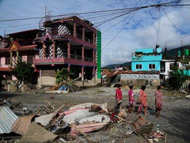
The catastrophic flash floods and debris flows along the Nepal-Tibet border, resulting in over 270 confirmed fatalities and more than 1,300 missing persons, represent a structural failure of high-altitude risk management. Moving past superficial reporting requires examining this event not merely as an act of arbitrary weather, but as the inevitable intersection of cryospheric instability, hydraulic bottlenecking, and high-density trans-border transit corridors.
The Cryospheric Mechanics of Failure
The primary causal mechanism of the disaster traced back to the upper reaches of the Lhende River basin near the Himalayan crest. Seismic and satellite data analyzed by the US Geological Survey confirmed that the initial trigger was a high-altitude structural collapse of ice and rock rather than a traditional tectonic earthquake.
When millions of tons of glacial mass fail, the physical transformation from solid ice to dynamic debris flow follows a distinct energetic progression:
- Potential Energy Conversion: High-elevation glacial tongues, destabilized by thermal degradation and warming atmospheric gradients, detach from bedrock.
- Kinetic Amplification: The mass plummets down vertical relief gradients, entraining loose moraine, soil, and rock fragments.
- Hydraulic Supercharging: Upon impacting river channels like the Bhote Koshi and Trishuli systems, the mixture creates a high-density hyper-concentrated flow capable of moving boulders the size of residential structures.
This dynamic creates a tsunami-like wall of water and slurry that outpaces standard meteorological early-warning lead times. Traditional river gauges downstream fail to register these events because the initial shockwave destroys the monitoring infrastructure before telemetry can transmit.
The Vulnerability Matrix of Trans-Border Infrastructure
The human cost of the disaster—concentrated heavily among foreign nationals, pilgrims traveling toward Mount Kailash, and local infrastructure workers—exposes systemic vulnerabilities in valley floor development. The topography of the Himalayas forces human activity into narrow, linear corridors where rivers have carved accessible paths.
Critical infrastructure assets, including hydropower projects, immigration checkpoints, and arterial roadways, are intentionally placed near riverbanks due to geographic constraints. This creates an asymmetric cost function:
- Hydropower Exposure: Run-of-the-river hydroelectric facilities situated along steep gorges act as physical traps. When debris flows arrive, installations like the Trishuli and Langtang projects face immediate structural inundation, capturing sediment that turns turbine halls into tombs.
- Transit Bottlenecks: Border crossings such as Gyirong Port and Rasuwagadhi operate as high-density concentration points. When a multi-story mudslide descends at high velocity, these administrative and commercial hubs offer zero lateral evacuation vectors.
- Communication Isolation: The sheer force of the slurry severs fiber-optic trunk lines, bridges, and road networks simultaneously, dividing the disaster zone into micro-segments that prevent coordinated triage during the critical first twelve hours.
Downstream Propagation and Search Dynamics
As the mass traveled south into lower elevations across the Chitwan and Nuwakot districts, the velocity of the flood decreased, but its destructive footprint widened through sediment deposition. The physical mechanics shifted from erosive destruction to burial. Infiltration of thick, heavy silt up to five feet deep encases buildings and bodies, rendering standard canine and visual search operations ineffective without heavy excavation machinery.
The rescue logistics face an inverse proportionality problem: the regions experiencing the highest casualty concentrations are simultaneously the most physically isolated by washed-out bridges and sheared cliffside roads. Airlifting survivors via military and private helicopters remains the sole viable logistics vector, yet rotorcraft capacity is constrained by volatile mountain meteorology and narrow canyon airspace.
Deploy heavy-lift rotary assets equipped with thermal imaging for immediate life-preservation sweeps along the entire Bhote Koshi-Trishuli drainage basin, while simultaneously establishing automated satellite-linked acoustic sensors upstream to provide downstream settlements with a mandatory minimum thirty-minute warning threshold for future cryospheric collapse events.


