The institutional integrity of infrastructure regulation depends on isolating technical analysis from executive mandates. When a proposed 250-to-259-foot monument—the "Independence Arch"—is planned within 3,000 feet of Ronald Reagan Washington National Airport (DCA), the intersection of civil engineering, political pressure, and risk management requires a formal breakdown. The dispute between executive momentum and legislative oversight highlights a core structural challenge: how the Federal Aviation Administration (FAA) evaluates physical obstructions in high-density, low-altitude terminal airspaces under regulatory codes.
Evaluating a mega-project of this magnitude requires mapping three distinct risk vectors: terminal airspace geometry, construction logistics, and regulatory protocols.
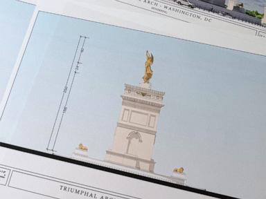
The Airspace Geometry Friction Coefficient
The primary technical bottleneck is the spatial relationship between the proposed structure and DCA's operational corridors. Commercial aircraft on final approach or departure at DCA operate at altitudes as low as 500 feet above ground level (AGL). A permanent structure scaling 259 feet introduces a vertical obstruction that eliminates a significant percentage of the safety margin within the National Capital Region (NCR) airspace.
This introduces an infrastructure risk formula where the hazard probability is a function of proximity to the runway centerline and the structure’s absolute height relative to the minimum vectoring altitude (MVA). Under Title 14 of the Code of Federal Regulations (CFR) Part 77, any structure exceeding 200 feet AGL automatically triggers an obstruction evaluation.
The proximity metrics for the proposed monument reveal an immediate operational constraint:
- Distance to Runway: 3,000 feet from DCA’s primary operational threshold.
- Structure Height: 250–259 feet AGL.
- Required Lighting: Red obstruction lighting, indicating entry into the regulatory baseline for flight hazards.
The FAA’s initial preliminary feasibility study indicated "no adverse impacts to operations," identifying red obstruction lights as a sufficient baseline mitigation tool. However, a preliminary review lacks the analytical depth of a full Aeronautical Study. A basic compliance check against Part 77 clearance planes does not account for micro-meteorological variables, such as wake turbulence patterns generated by the monument’s surface area, or the visual degradation caused by low-altitude glare close to active approach paths.
Construction-Phase Logistics and Temporary Obstructions
While the finished monument presents a permanent static variable, the construction phase introduces dynamic, higher-risk temporary vectors. According to preliminary reports from the National Park Service (NPS), building the concrete and granite-clad edifice requires an aggressive three-year timeline. To achieve this, operations are projected to run up to 20 hours per day.
This operational intensity creates a second, more severe airspace bottleneck: the deployment of heavy industrial equipment.
- Crane Operating Height: Heavy lifting equipment is projected to reach altitudes between 300 and 320 feet AGL.
- Temporal Exposure: 20 hours of daily operation over a 24-to-36-month window exponentially increases the probability of a low-visibility or mechanical failure incident.
- Visual Complexity: A 320-foot temporary structure operating continuously within a highly restricted flight zone complicates air traffic control sequencing, particularly during bad weather or emergency diversions.
The risk profile of this construction phase cannot be managed by static red lighting alone. The presence of high-reaching cranes within the DCA departure and approach corridor demands temporary changes to instrument approach procedures (IAPs), which directly lowers the airport's arrival rate (AAR) during marginal weather conditions.
The Legacy of Airspace Complexity
The debate over the monument’s approval does not happen in a vacuum; it occurs within one of the most complex, politically sensitive airspaces in the world. Legislative concerns, voiced by Senate aviation subcommittee leaders, highlight recent systemic strains, including a fatal midair collision between a commercial regional jet and a U.S. Army helicopter in the NCR terminal environment.
This historical context demonstrates that regulatory safety margins are cumulative rather than isolated. Introducing a major physical obstacle into an environment already crowded with strict security perimeters (P-56 airspace), heavy helicopter traffic, and dense commercial routes reduces the system's ability to absorb unexpected pilot or air traffic control errors.
Furthermore, mega-projects that are pushed through on accelerated timelines often create blind spots in multi-agency coordination. When the FAA, National Park Service, and Commission of Fine Arts operate under conflicting mandates—such as balancing aesthetic commemorative goals against strict aeronautical margins—the risk of regulatory fragmentation rises.
Systemic Limitations of Preliminary Mitigation
The current mitigation strategy relies on standard marking and lighting protocols. While effective for isolated towers, this approach has clear limitations when applied to large, block-like architectural structures in a busy airport environment:
- Visual Overload: In high-density environments, adding more high-intensity lighting systems can contribute to pilot confusion or mask existing runway lighting arrays.
- Instrument Disruption: Massive concrete and steel structures can cause minor radar reflections or signal degradation for ground-based instrument landing systems (ILS), requiring detailed electromagnetic assessments that are rarely included in early feasibility reviews.
- Human Factors: Relying on pilots to visually see and avoid a 259-foot obstacle assumes perfect visibility and attention during the most demanding parts of a flight.
Strategic Recommendation
The FAA must decouple its upcoming comprehensive Aeronautical Study from any external political timelines or expedited construction schedules. Moving forward, the agency needs to apply an advanced quantitative risk assessment that treats the construction equipment (the 320-foot cranes) as the operational baseline, rather than just evaluating the completed 259-foot arch.
Regulatory approval should be withheld until a full simulation models the impact of the structure on DCA's arrival and departure capacities during category-II weather conditions. If the modeling shows a measurable drop in safety margins or operational efficiency, the project must either be moved outside the terminal radar approach control zone or scaled down to fit below the Part 77 obstruction threshold.
An on-the-ground look at the visual impact and location of this project can be found in this report on the FAA's safety light requirements for the Trump Arch, which explains the preliminary review findings and the upcoming full aeronautical study.


