A dangerous mix of tropical moisture and severe midwestern storms is hammering a massive stretch of the country right now. If you think your local drainage system or power grid is ready for the new reality of summer storms, you're probably wrong.
The remnants of Tropical Storm Arthur are currently unloading massive amounts of water across the Gulf Coast. Meanwhile, just a day earlier, a violent line of severe weather tore through the Midwest, leaving a trail of collapsed buildings, ripped roofs, and dark neighborhoods.
This isn't just a standard week of bad weather. It's a clear warning about how vulnerable our infrastructure remains when multiple weather systems strike simultaneously. Here's exactly what's happening on the ground and what you need to do to protect your property and your family.
Arthur Floods the Gulf Coast with Intense Rainfall
Tropical Storm Arthur made landfall as the first named storm of the 2026 Atlantic hurricane season before being downgraded to a low-pressure area along the upper Texas coast. Don't let the word downgraded fool you. The system is still incredibly dangerous.
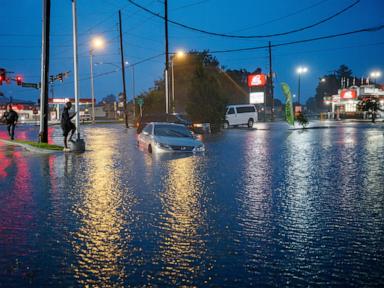
Right now, southern Louisiana and Mississippi are taking the brunt of the assault. The National Weather Service reported rainfall rates reaching a staggering 3 inches per hour in some spots on Thursday morning. That's a volume of water that standard municipal drainage systems simply cannot handle.
The National Hurricane Center expects Arthur's remnants to dump anywhere from 4 to 8 inches of rain across Louisiana, Mississippi, Alabama, Georgia, and the Florida Panhandle. Localized areas could see even more.
New Orleans Mayor Helena Moreno confirmed that city crews have been deploying barricades in known low-lying flood zones and preparing rescue boats. Sandbag stations are popping up all over Louisiana as residents try to keep the rising waters out of their living rooms. Streets are already transforming into rivers, making driving completely impossible in the hardest-hit zones.
The Midwest Rebounds from Violent Tornado Damage
Before Arthur even finished soaking Texas and Louisiana, a separate line of intense severe storms swept across the Midwest on Wednesday evening. The damage was fast and destructive.
Illinois, Indiana, and northern Kentucky got hit the hardest. More than 130,000 homes and businesses lost power across the region as high winds snapped utility poles and shattered trees.
In Effingham, Illinois, a confirmed tornado caused severe damage just north of the city. Effingham Fire Chief Brant Yochum reported that crews spent the night responding to collapsed structures, gas leaks, car crashes, and blocked roadways. An automobile museum and an auto parts complex in the area suffered catastrophic structural damage.
Over in Florence, Kentucky, strong winds and a suspected tornado ripped roofs and siding directly off buildings. Debris from a nearby school building was thrown directly into residential backyards, shaking houses so violently that residents described the scene as looking like Armageddon. Miraculously, despite the heavy structural destruction across multiple states, officials have reported only a few minor injuries and no deaths.
How to Prepare for the Next Wave of Flash Floods
If your area is under a flash flood watch or warning, you can't afford to wait until the water reaches your front door. Flash floods happen in minutes, not hours.
First, clear your gutters and nearby storm drains immediately. Blocked drains are the primary cause of localized street flooding that ruins parked cars and floods basements. If you see debris blocking a storm grate on your street, pull it away if it's safe to do so.
Second, move your vehicles to higher ground. Do not leave your car parked in an underground garage or a known low-lying street. Thousands of vehicles are totaled every year simply because owners hesitated to move them a few blocks uphill.
Third, pack a go-bag and know your evacuation route. If water starts entering your home, you need to move to the highest floor possible. Never try to walk or drive through flooded roads. It takes just six inches of moving water to knock you off your feet, and only two feet of water to float a full-sized SUV.
What to Do During an Extended Power Outage
With tens of thousands of people still waiting for the lights to come back on in the Midwest and Gulf states, grid vulnerability is top of mind. Managing an outage requires a few smart tactical moves to protect your appliances and your health.
- Unplug your electronics. When the utility company restores power, a massive electrical surge can rush through the lines. This surge can instantly fry computers, televisions, and smart appliances. Leave one light switched on so you know when the grid is back up, but unplug everything else.
- Keep the fridge closed. An unopened refrigerator will keep food safely cold for about four hours. A full freezer can hold its temperature for up to 48 hours if you keep the door shut. If you open the door to look inside, you let the cold air escape and speed up spoilage.
- Never run a generator indoors. Portable generators produce carbon monoxide, an odorless, deadly gas. Keep generators at least 20 feet away from your house, and never run them in a garage, basement, or porch.
Pay close attention to local emergency broadcasts. The active storm tracks are shifting toward the central Appalachians and New England next. Check your sump pumps, test your flashlights, and make sure your weather alerts are turned on.