Single-month mortality figures tied to Indonesian fire smoke—such as an estimate of 3,560 deaths in September—capture acute seasonal damage while obscuring the recurring structural mechanisms that turn land clearing into a public health crisis. To evaluate fire-driven air pollution rigorously, analysts need a structured framework built on four components: The Combustion-to-Exposure Chain, The Epidemiological Attribution Function, The Institutional Incentive Matrix, and The Intervention Trade-Off Ledger. Applying this blueprint separates observed meteorological and land-use dynamics from modeled mortality estimates, clarifies how smoke travels across borders and administrative boundaries, and shows where policy interventions succeed or stall.
Headline mortality numbers from smoke episodes rarely measure direct, instantaneous suffocation. Instead, they typically reflect attributable excess mortality estimated through epidemiological concentration-response functions applied to modeled or monitored concentrations of fine particulate matter ($PM_{2.5}$). A known fact in atmospheric physics and public health is that peatland and forest fires generate dense plumes rich in $PM_{2.5}$—particles with an aerodynamic diameter of 2.5 micrometers or smaller—capable of penetrating deep into the respiratory tract and entering the bloodstream. By contrast, exact monthly death counts linked to a specific fire event are educated statistical estimates unless verified through granular vital-registration and hospital-admission time-series modeling. Treating a modeled monthly figure as a direct headcount of immediate fire fatalities misrepresents how population harm accumulates across cardiovascular, respiratory, and vulnerable age cohorts.
The Combustion-to-Exposure Chain
Fire smoke in Indonesia is not a uniform atmospheric blanket; it is the output of an operational sequence linking land management, soil hydrology, weather regimes, and human contact. Treating "air pollution" as a standalone variable misses the upstream decisions that supply fuel and ignition.
Fuel Type and Combustion Physics
Two distinct fuel regimes drive severe smoke episodes in Indonesia: mineral-soil tropical forest and degraded peatland. Mineral-soil clearing produces intense flaming combustion for relatively short periods, lofting smoke higher into the atmosphere when convection is strong. Peatland fires behave differently. Peat consists of partially decayed organic matter accumulated over millennia under waterlogged conditions. Once drained for agriculture, plantation expansion, or infrastructure access, peat dries out and burns via smoldering combustion—a slow, low-temperature, oxygen-limited oxidation process.
Smoldering peat fires are operationally difficult to extinguish because combustion can continue beneath the surface even after surface flames appear controlled. They also emit high ratios of particulate matter, carbon monoxide, and semi-volatile organic compounds per unit of fuel consumed compared with open flaming fires. When dry conditions coincide with land preparation, smoldering zones can persist for weeks, sustaining elevated baseline particulate concentrations rather than creating a single brief spike.
Hydrological Drying and Climate Modulation
Fuel availability is governed heavily by water tables and seasonal rainfall. In normal or wet years, high soil moisture in peat domes acts as a natural firebreak. During dry seasons—and especially when El Niño-Southern Oscillation (ENSO) phases or positive Indian Ocean Dipole (IOD) events suppress rainfall across Maritime Southeast Asia—evapotranspiration outpaces precipitation, lowering water tables across drained peatlands.
Climate anomalies act as a force multiplier, not a sole cause. A dry monsoon widens the operational window during which fire spreads easily and makes suppression crews harder to deploy into remote or soft-ground terrain. Yet dry weather alone does not ignite drained peat across thousands of hectares; human ignition sources and altered drainage networks supply the necessary preconditions.
Spatial Dispersion and Population Exposure
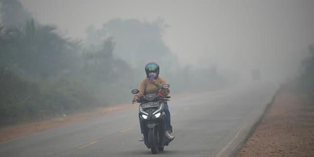
Once emitted, pollutants move according to boundary-layer meteorology, terrain, and wind transport. Smoke plumes do not respect provincial borders or national jurisdictions. Prevailing winds during dry months can carry dense haze across Sumatra and Kalimantan and into neighboring states such as Malaysia and Singapore, turning a domestic land-management failure into a regional diplomatic and public health issue.
Exposure depends on where people live, work, and move relative to the plume. Outdoor agricultural workers, informal laborers, children, older adults, and individuals with pre-existing cardiopulmonary conditions face unequal risk profiles. Indoor air quality offers only partial protection in buildings with high air-exchange rates or lack of filtration, meaning ambient $PM_{2.5}$ spikes translate rapidly into indoor inhalation burdens.
The Epidemiological Attribution Function
When analysts encounter a specific monthly death toll attributed to fire smoke, they are looking at the output of a multi-step estimation model rather than a single direct measurement. Understanding this structure prevents over-interpreting precision where uncertainty remains substantial.
- Baseline Population and Mortality Rate: The starting demographic size of the exposed population and its expected baseline death rate under non-crisis conditions.
- Exposure Concentration Surface: Estimated daily or monthly $PM_{2.5}$ concentrations across grid cells, derived from satellite aerosol optical depth, chemical transport models, and sparse ground-level air quality monitors.
- Counterfactual Baseline: The estimated $PM_{2.5}$ level that would have existed in the absence of fire emissions—a critical assumption because background urban and industrial pollution already exists.
- Concentration-Response Function (CRF): A relative-risk curve—often adapted from global burden-of-disease or cohort studies—that links incremental increases in $PM_{2.5}$ to changes in all-cause or cause-specific mortality risk.
- Lag Structure: The timing of health effects, recognizing that cardiovascular and respiratory risks can manifest both acutely during high-exposure days and across short lagged windows.
This creates a methodological bottleneck: ground-monitoring sparsity and counterfactual sensitivity. Where surface sensor networks are thin, modelers rely heavily on satellite retrievals and dispersion modeling, which face challenges under heavy cloud cover, complex vertical smoke layers, or rapid shifts in humidity. Furthermore, shifting the counterfactual $PM_{2.5}$ baseline or selecting a different CRF slope can materially alter total estimated deaths even when the underlying smoke event is identical.
A rigorous reading therefore separates two layers of evidence. The known physical mechanism is that acute surges in fine particulate matter increase cardiovascular and respiratory stress in exposed populations, elevating short-term mortality risk. The modeled estimate is the specific numeric count—such as 3,560 deaths in a given month—which depends on input datasets, spatial resolution, and epidemiological assumptions that should be audited rather than quoted uncritically.
The Institutional Incentive Matrix
Why do recurring smoke episodes persist despite decades of regulatory pledges, corporate zero-deforestation commitments, and emergency response deployments? The answer lies in misaligned incentives across landholders, local enforcement capacity, commodity markets, and emergency fiscal cycles.
Land Economics and Clearing Cost Asymmetry
Fire remains a low-cost tool for clearing vegetation, managing agricultural residues, and asserting or preparing land claims in remote areas. Mechanical clearing requires heavy equipment, fuel, transport logistics, and time—costs that are often prohibitive on fragmented plots or waterlogged, stump-heavy terrain. Fire is fast and cheap in the short run because the landowner captures the immediate clearing efficiency while externalizing smoke damage onto distant populations and regional economies.
Enforcement Gaps Across Jurisdictional Layers
Governance over land, peat restoration, and fire control spans national ministries, provincial authorities, district administrations, and village-level institutions. In practice, enforcement faces structural friction: vast geographic areas with limited road access, overlapping or contested land tenure, and constrained local monitoring capacity during peak dry months. Detecting a hotspot via satellite is only the first step; verifying ignition responsibility, proving legal liability on degraded or disputed parcels, and enforcing penalties on the ground require operational bandwidth that is frequently stretched thin during simultaneous outbreaks.
Reactive Crisis Spending Versus Preventive Maintenance
Public and institutional attention surges when visibility drops, schools close, flights face disruption, or transboundary haze triggers diplomatic friction. Emergency suppression mobilizes personnel, water-bombing aircraft, and health advisories under intense time pressure. Yet fighting established peat fires is far more resource-intensive than maintaining canal blocks, rewetting peat domes, and enforcing land-use rules before the dry season peaks. When budgets and political urgency concentrate on acute response rather than year-round hydrological and governance maintenance, the system remains vulnerable to the next dry cycle.
The Intervention Trade-Off Ledger
Managing fire-driven air pollution requires matching interventions to the stage of the causal chain—prevention, early suppression, or exposure reduction—while accounting for real-world operational constraints. No single lever resolves the problem on its own.
- Peat Rewetting and Canal Blocking: Raising water tables by blocking drainage canals directly reduces peat flammability and smoldering risk. The operational limitation is hydrological and social: canals were often built to drain land for cultivation, so blocking them can affect local drainage, smallholder access routes, or adjacent crops if community alignment and water-management planning are weak.
- Fire Bans, Monitoring, and Concession Accountability: Combining near-real-time hotspot alerts with supply-chain traceability and legal sanctions raises the expected cost of illegal burning. Its limitation is attribution and enforcement lag—distinguishing deliberate arson from escaped agricultural fire or natural lightning, and pursuing violations across complex land ownership structures.
- Rapid Ground and Aerial Suppression: Early detection paired with rapid-response ground teams and aerial assets can contain emerging fires before they entrench in deep peat. Its limitation is scale and terrain: during peak dry spells with hundreds of active fires, aerial water drops often cool surface heat without extinguishing deep smoldering peat, while remote access slows ground crews.
- Public Health Advisories, Masks, and Clean Air Shelters: Distributing respirator masks (such as N95/KN95 standards rather than loose cloth masks), issuing air-quality alerts, and creating filtered indoor spaces reduce personal inhalation during severe episodes. Its limitation is behavioral and socioeconomic: outdoor workers cannot easily stop earning daily wages for weeks, improper mask fit lowers real-world filtration, and broad population coverage with clean-air spaces is costly to scale.
From an operational standpoint, prevention beats suppression on cost-effectiveness, while exposure reduction protects vulnerable groups when containment lags. A practical sequence for practitioners managing seasonal smoke risk follows four steps:
- Map High-Risk Peat and Hotspot Corridors Before the Dry Season: Overlay drained peat maps, historical fire ignition clusters, wind trajectories, and population density to prioritize where preventive resources go first.
- Audit Water-Table Readiness and Suppression Staging: Verify canal-blocking infrastructure, community fire-brigade readiness, and rapid-response staging locations ahead of peak dry months rather than waiting for visibility to collapse.
- Separate Real-Time Hazard Alerts from Modeled Health Estimates: Communicate actionable daily air-quality tiers and protective steps to the public while keeping epidemiological mortality estimates clearly labeled as modeled assessments with stated assumptions.
- Target Protective Resources to High-Exposure and High-Vulnerability Cohorts: Direct filtered spaces, appropriate respirators, and clinical triage capacity toward outdoor workers, children, older adults, and patients with chronic respiratory or cardiovascular conditions.
Every intervention carries boundary conditions. Rewetting programs stall without local livelihood alternatives; regulatory crackdowns face friction where land tenure is ambiguous; public health advisories lose credibility if guidance ignores economic survival constraints. Recognizing these trade-offs prevents over-promising quick fixes in a complex socio-ecological system.
Strategic Recommendation
Decision-makers and analysts evaluating fire smoke mortality should replace headline single-month death figures with a quarterly risk-and-readiness scorecard that tracks three metrics together: drained-peat water-table or fire-proneness indicators ahead of the dry season, population-weighted $PM_{2.5}$ exceedance days during smoke months, and modeled excess mortality paired with explicit confidence bounds and input assumptions. Anchoring policy and investment decisions to pre-season hydrological readiness and targeted exposure protection—rather than reacting solely to peak-month mortality headlines—is the most reliable way to reduce recurring harm when dry weather returns.