A towering wall of mud, ice, and rock tore through the Himalayas, changing the geography of the Nepal-Tibet border in a matter of minutes. When valleys vanish under millions of tons of debris, finding out what actually happened is nearly impossible from the ground. Roads are gone, bridges are wiped out, and communication lines are dead. That is why scientists and disaster response teams immediately looked upward.
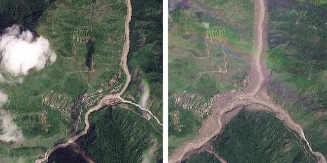
High-resolution satellite imagery captured by providers like Planet Labs laid bare the sheer scale of the devastation along the Bhote Koshi and Trishuli river corridors. What used to be steep, green mountain slopes turned into barren expanses of brown sediment almost overnight. These eyes in the sky did more than just take pictures. They solved a dangerous mystery about what triggered the catastrophe.
From False Alarms to Glacial Reality
Initial reports pointed fingers in multiple directions. Some officials suspected an earthquake caused a sudden collapse, pointing to seismic data recorded around the time of the disaster. Others argued over whether a barrier lake upstream had burst its banks. Ground access was completely blocked, leaving authorities guessing while hundreds remained missing.
Geologists reviewing sequential satellite data quickly corrected the narrative. The before-and-after frames revealed that the snout of a high-altitude glacier at roughly 5,200 meters elevation had broken off. This massive block of ice and rock plunged over a thousand meters straight onto the valley floor below.
The movement was so violent that it generated its own seismic signature, tricking monitoring stations into registering a distinct earthquake when the ground motion was actually the result of the massive collapse. It is a stark reminder of how high-altitude environments can shift without warning, leaving downstream communities with zero time to react.
The Human Cost Along the Border
Satellites capture pixels, but on the ground, the reality is heartbreaking. Districts like Rasuwa in Nepal and Gyirong County across the border in Tibet bore the brunt of the slurry surge. Entire border settlements, hydropower stations, and vital transport links were swallowed by thick, viscous mud.
Rescue helicopters couldn't even land in places like Syabrubesi because the rivers were raging far above their normal banks. Official numbers show a climbing death toll, with hundreds more missing as rescue workers struggle through unstable terrain. Downstream communities in northern India even went on high alert as the swollen river systems carried debris toward the plains.
Why the Himalayas Are Changing Faster Than Ever
This disaster is part of a much larger, terrifying trend across the mountain range. Global heating is eating away at the roof of the world at an unprecedented pace. United Nations assessments show that Himalayan glaciers have been losing ice mass at historic rates, shrinking drastically over the past few decades.
When glaciers melt and thin out, they become structurally unstable. Pockets of water pool inside or beneath them, and sudden temperature spikes weaken the ice walls holding everything together. When a section fails, it triggers a chain reaction. Rock, ice, and soil mix into a liquid batter that accelerates down steep mountain canyons, transforming normal rivers into destructive tsunamis of mud.
Governments and local populations now face an uphill battle. Traditional early warning systems are failing because these glacial outbursts happen in remote zones where traditional monitoring equipment cannot survive. Moving forward, authorities must integrate real-time satellite radar and optical tracking to spot swelling glacial lakes and unstable slopes before they let go. If you live downstream from these fragile mountain ecosystems, understanding the speed of these events changes everything about how emergency planning has to work. Keep an eye on local disaster management updates, support regional climate resilience initiatives, and push for better upstream monitoring before the next valley gives way.