The air in the high valleys smells of cold stone and impending rain. Up there, where the peaks of the Himalaya scrape the blue until it turns the color of bruised steel, the world feels permanent. It is easy to look at those frozen giants and believe they are immutable, frozen in time and posture, watching over the green and terraced foothills below.
Then the mountain moves.
For generations, the collective anxiety of the Hindu Kush Himalaya region centered on a singular, terrifying protagonist: the glacial lake outburst flood. Scientists gave them an acronym, GLOF, and villagers learned to listen for the low, tectonic groan that meant a wall of water had breached a terminal moraine. We pictured ice melting into slush, earthen dams bursting under the weight of turquoise meltwater, and roaring torrents swallowing villages whole. It was a clean narrative. A tragic one, but straightforward. Ice melts. Water falls.
Satellites, looking down with cold and unblinking electronic eyes, have just rewritten that story.
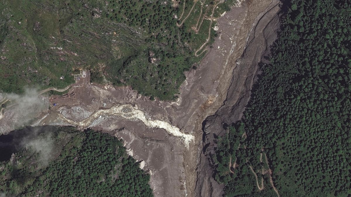
Consider what happens when the sky itself decides to conspire with the earth. Recent orbital imagery capturing the catastrophic flooding in Nepal reveals a terrifying truth. The water did not simply rush down from a thawing glacier. The disaster was born in the clouds, fueled by a relentless, atmospheric fire hose of monsoon moisture that smashed against the mountain walls, dropping unprecedented volumes of rain directly onto slopes that had never been asked to carry such a weight.
It was not just a glacier. It was an avalanche of sky.
To understand why this shift in understanding matters, imagine standing on a steep hillside in the shadow of Annapurna. You have lived through monsoons your entire life. You know the rhythm of the rains—the heavy, rhythmic drumming on tin roofs, the smell of wet soil, the swollen rivers that run the color of chocolate milk by August. You clear your irrigation channels. You reinforce your stone walls. You prepare for the water you know.
You do not prepare for a cloudburst so intense that the hillsides liquidfy.
When rain falls at rates defying meteorological memory, the ground stops behaving like earth. It behaves like fluid. Steep, soil-draped mountain flanks, destabilized by years of subtle warming and sudden, violent cloudbursts, let go all at once. Whole forests slide into canyons. Roads vanish. Rivers do not merely rise; they choke on mud, rock, and entire chunks of mountainside, turning into moving slurry that behaves like liquid concrete.
This is the hidden mechanics of modern climate catastrophe. We look at the obvious suspects—the shrinking ice, the retreating tongues of ancient glaciers—because they are visible monuments to a warming planet. But the true danger often hides in the invisible mechanics of the atmosphere. Warmer air holds more moisture. Physics demands it. When that supersaturated air hits the towering topography of the Himalayas, it squeezes out like a wet sponge wrung by a giant hand.
The satellites show us the scars. Landslides sprawling across valleys like raw wounds. Riverbeds choked so high with debris that bridges built fifty feet above the water line now sit flush with the silt.
Walking through these valleys after the waters recede is an exercise in profound disorientation. The landmarks are gone. A boulder the size of a two-story house sits in the middle of a primary school courtyard, dropped there by a river that forgot its boundaries. The local tea shop owner, a man whose family has poured sweet milk tea for travelers for three generations, points to a dry gully fifty yards from his porch. Last month, that gully didn't exist. Now it is a scar of grey mud that swallowed his neighbor's barn.
He looks up at the peaks, his expression less afraid than profoundly tired. He tells you the mountain feels different now. Unpredictable. As if the ancient contract between the land and the people who farm it has been voided by a party neither of them can see.
We have spent decades building early-warning systems aimed upstream, watching the glacial lakes for signs of stress, installing sensors in high-altitude ice. Those systems are vital, but they are looking backward at the last crisis. The Nepal floods demonstrate that the threat profile has mutated. The danger is no longer just a static block of ice giving way under the sun. It is a dynamic, atmospheric volatility that can turn a clear afternoon into a geological catastrophe in the span of two hours.
To adapt to this reality requires a complete rewiring of how we perceive disaster risk. It demands that we couple our ice-monitoring stations with hyper-local meteorological radar capable of tracking extreme rainfall events in real time across impossibly rugged terrain. It means moving vulnerable settlements not just away from known glacial paths, but mapping the ephemeral drainage lines of extreme cloudburst zones—areas that have no history of flooding simply because the sky has never rained this hard before in human memory.
The ice is retreating, yes. But the rain is advancing.
And as the monsoon winds carry more moisture into the thin, high air of the roof of the world, the mountains will continue to test the limits of human resilience. The satellite images are not merely a technical update on a weather event. They are an eviction notice for our assumptions, a stark reminder that the planet we think we know is shifting beneath our feet and above our heads, rewriting the rules of survival one storm at a time.



