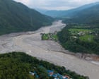
Geographic isolation in high-altitude border zones transforms routine meteorological events into systemic communication failures. When catastrophic flash floods and mudslides obliterated infrastructure along the Nepal-Tibet border, telecommunications networks collapsed instantly, severing contact with hundreds of foreign nationals, including dozens of Australian citizens undertaking spiritual pilgrimages to Mount Kailash. The subsequent uncertainty surrounding missing persons highlights a recurring vulnerability in remote-region disaster response: the time lag between physical survival and digital notification.
The structural anatomy of cross-border disaster zones relies on three primary variables that dictate crisis resolution timelines. Physical infrastructure destruction creates the first barrier, as washed-out bridges and submerged roadways isolate mountain valleys from central command. Telecommunication redundancy failure forms the second barrier, leaving travelers without localized cell coverage or functioning satellite relays. Bureaucratic jurisdiction fragmentation constitutes the third variable, requiring coordination between distinct regional authorities, foreign consular offices, and private tour operators who operate across the Himalayan frontier.
When an unaccounted-for traveler re-establishes contact, as recently occurred with multiple Australian citizens located safely within Tibet, the event exposes the operational mechanics of delayed verification. In remote terrain, survival does not immediately equate to connectivity. Survivors often remain sheltered in localized high-ground camps or monastic outposts that lack electrical power and functional transmission lines. The transition from missing to verified safe depends on three sequential clearance steps: physical relocation to an area with operational communication nodes, bilateral consular identification through departments such as the Australian Department of Foreign Affairs and Trade, and public status updates released via official channels.
Crisis communication protocols in mountainous corridors must account for predictable infrastructure bottlenecks. Tour operators specializing in Himalayan itineraries often operate on decentralized local schedules, complicating initial headcounts. When a sudden hydrological surge sweeps through valleys like Gyirong, emergency response teams cannot deploy immediate digital tracking because baseline telemetry does not exist for independent trekkers and group excursions alike.
Analyzing the efficiency of rescue verification requires evaluating the friction within information pipelines. Official bodies rely on ground reports transmitted via satellite phones or military radio links, which suffer from high latency. Families searching for updates experience a data vacuum, where the absence of news is frequently misconstrued as structural failure rather than mere transmission delay. Understanding this operational lag prevents misallocating scarce emergency search assets toward individuals who have already reached safety but remain trapped behind offline boundaries.
To optimize future crisis response in high-risk border regions, institutional stakeholders must implement decentralized satellite check-in mandates for commercial tour groups, establish standardized cross-border telemetry sharing protocols between Nepalese and Chinese regional authorities, and deploy portable micro-cell relay units equipped with emergency battery arrays along primary trekking routes.